Buzzword Breakdown – GPS
Nov 19 2024 What is it? How does it work? Will GPS location tracking work for me?
This helpful guide will get you started with some ideas on how you can get GPS working for your farming operation. If you’re an expert already using GPS skip ahead to find out how to improve common problems with your GPS signal.
So, what is GPS?
GPS stands for Global Positioning System. It is a satellite-based navigation system allowing you to locate where you are, anywhere on your farm, within a distance of about 5 meters. By combining GPS with a map overlay (like on Google Maps, or Google Earth), a GPS device or piece of machinery with GPS will tell you your whereabouts in a paddock or field, where a boundary line is, or where you’re planting something.
Another good thing about GPS is that it works in all weather conditions.
What are the uses of GPS in farming?
There are plenty of simple to deploy solutions that will get you started with GPS and they don’t cost more than a few hundred dollars. They’re easy to use and will provide you with benefits you can use right away.
What are some common uses of GPS in agriculture?
- GPS mapping for precision and digital farming activities
- using location information collected by GPS receivers for mapping field boundaries
- for marking irrigation systems, and where pipes and outlets are
- for marking problem areas in crops such as areas where there are weeds or disease
- vehicle or equipment tracking
Search ‘GPS’ or ‘location tracking’ on AgTech Finder and you will find several solutions that can help many different types of farms and agribusinesses become more productive, efficient, safe, and profitable using GPS.

What are the most commonly purchased GPS devices?
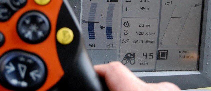
One of the most common ‘entry level’ GPS farming devices and equipment include in-cab GPS systems for spatially oriented tasking and tracking. These are often much more accurate than the GPS on your smartphone or tablet, but in some instances you may also need an external GPS receiver. These external GPS receivers partner with your smart device’s basic GPS unit to increase the accuracy required for agriculture use. The external GPS receiver pairs via Bluetooth or Wi-Fi and uses a correction signal to boost accuracy, in some instances to less than half a meter.
Using in-cab GPS systems as an example, you’ll see how you can use GPS to help with:
- tracking where you are and where you have been
- knowing what you have done
- knowing which inputs have been placed where, and at what rate
- showing you what needs attention
- creating imagery showing any variability, and where work needs to be carried out in which field
- dropping pins as you go to remind you of the tasks that need doing, and where
For more GPS solutions try typing ‘GPS’ into the search bar of AgTech Finder, or click on this shortcut.

Using GPS to create a map of your farm
The accuracy of GPS is really useful in helping create farm maps with precise acreage for field areas. This allows you to better manage irrigation and reduce the costs of the use of fertilisers and pesticides. GPS also allows farmers to accurately navigate to specific locations in the field, year after year, to collect soil samples or monitor crop conditions.
By using GPS, you can also more accurately manage pest, insect, and weed infestations in the field by pinpointing problem areas and recording them on your GPS map. This information will then help you make future management decisions about what to plant, and how to treat.
The same field data can also be easily shared with machinery operators or aircraft sprayers, enabling accurate swathing of fields without use of human “flaggers” to guide them. Crop dusters equipped with GPS are able to fly accurate swaths over the field, applying chemicals only where needed, minimising chemical drift, thereby reducing costs and also benefiting the environment.
What are some of the common problems of GPS tracking?
GPS has become the norm for tracking vehicles, machinery, livestock and more. But in many cases the equipment that uses GPS has been tested in conditions where the GPS signal is strong and uninterrupted. In some instances where signal strength might drop in and out there are obviously going to be limitations (remember, the signal is coming from a satellite way up there and even things like the way an antenna is pointing can affect the signal).
Remember though! Just because something might not work as expected when you take it out of the box – there are often small changes or configurations that can make a big difference. Before using any device (or a new model or version) always read the manual. The manual will often contain important pieces of easily missed information, safety reminders, and best practice tips that will cost you time if you ignore them and race ahead.
Common problems encountered with agtech devices that use GPS are listed below.
These are just some of the ones some of our AgTech Finder community have encountered. If you’ve got others let us know by emailing agtechfinder@foodagility.com, or by using @agtechfinder on Twitter, or messaging us from the AgTech Finder Facebook page.
1. The GPS signal isn’t great or keeps dropping in and out
A weak GPS signal may result in location accuracy problems – “why is the GPS telling me to drive into a neighbouring paddock?” The good news is that you can take actions or purchase an extra bit of kit that can strengthen a GPS signal. Weak signals are almost always due to a problem with the GPS antenna (not the satellite and not the weather). What you will usually find is that the GPS is receiving a weak signal because the GPS antenna is either not properly positioned with “line of sight” to the sky (where the satellites are). This can be caused by a number of things:
- tall structures nearby like buildings or silos
- power lines or antennas that may cause interference
- tunnels (remember GPS needs “line of sight”
- large metal sheet sheds or garages built with lots of steel
- placement of the antenna inside the vehicle with no “line of sight” to the sky
2. There is no signal at all. Everything is plugged in and working as it should be but it’s as if the satellite signal isn’t there at all?
Device configuration is one of the most likely reasons you will get no signal at all. If everything is on, the cables are where they should be, you have a clear uninterrupted view of the sky and plenty of battery – but are still not getting any GPS signal – turn to your configuration guide.
3. Does my GPS device need to be connected to the internet?
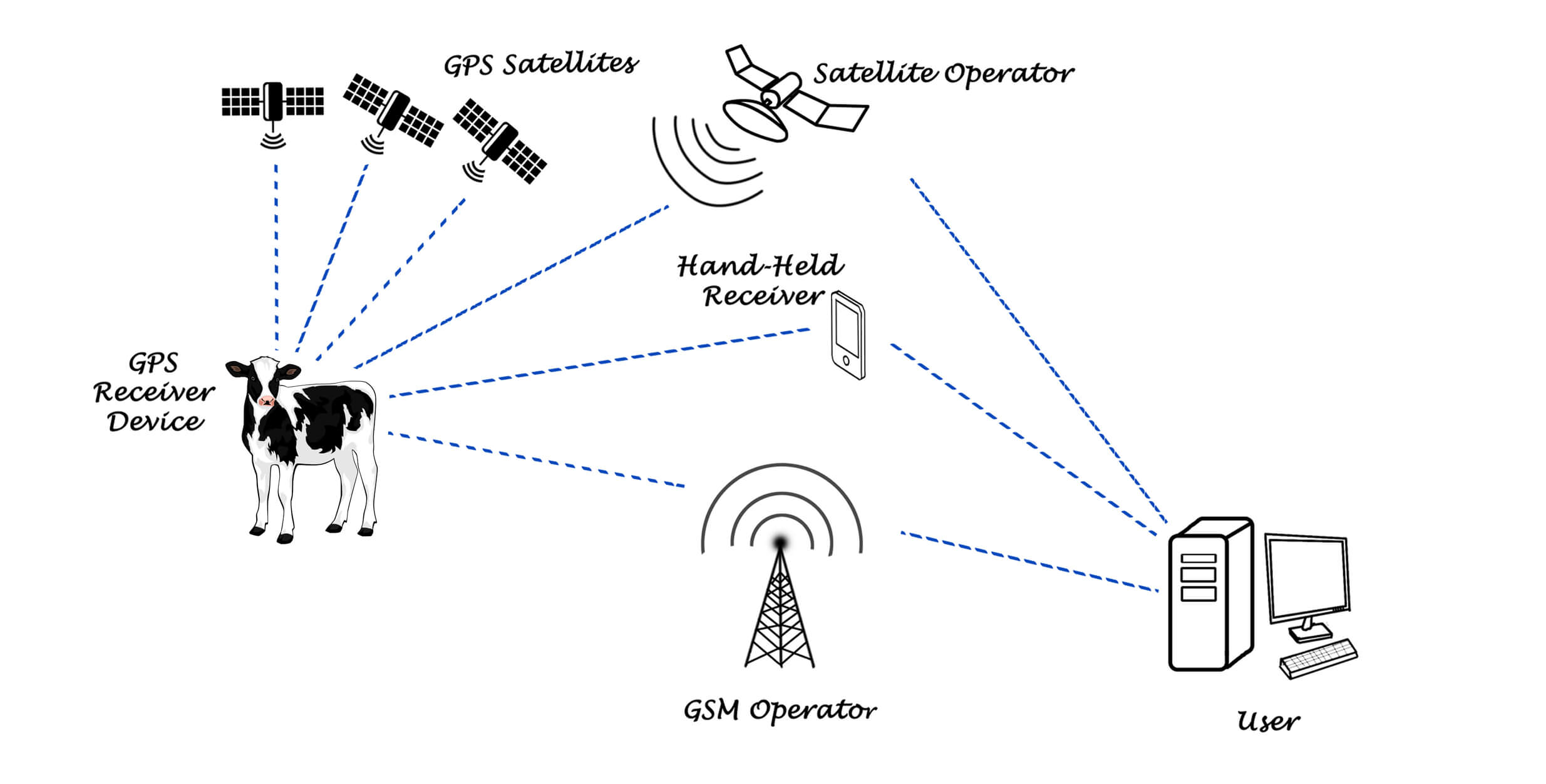
There are two types of GPS devices. Firstly, there are those that operate without need to be connected to the Internet. Then, there those that share their location to a connected device, usually to a Cloud based service or back to some service provided by the GPS device provider (a web service or sorts).
If your device requires an Internet connection one of the common methods of getting one is by pairing the device with your phone that is getting a 3G or 4G signal from a tower nearby.
However, if you know your phone has no connectivity on your farm, you should first sort that out before purchasing a GPS device that needs connectivity to the Internet when you’re out in the field.
Some devices may let you connect them to your laptop at the end of the day and then download all the data to an app on the laptop or into the Cloud.
4. Everything with my SIM, my network and signal is ok, but the GPS device still isn’t working.
One common problem encountered by first-time users of GPS trackers that link back into servers is that their GPS device time zone isn’t set correctly. In Australia we have three main coordinated universal times, also known as UTS time zones. These include the Australian Western Standard Time (AWST; UTC+08:00), Australian Central Standard Time (ACST; UTC+09:30), and Australian Eastern Standard Time (AEST; UTC+10:00).
When you’re setting up your GPS device make sure you set it to the correct time zone, or default set it to ‘0’ zero (UTC), or your data will be logged to the wrong time. This is quite common, and in some cases your GPS device may not work at all until the correct time zone is entered.
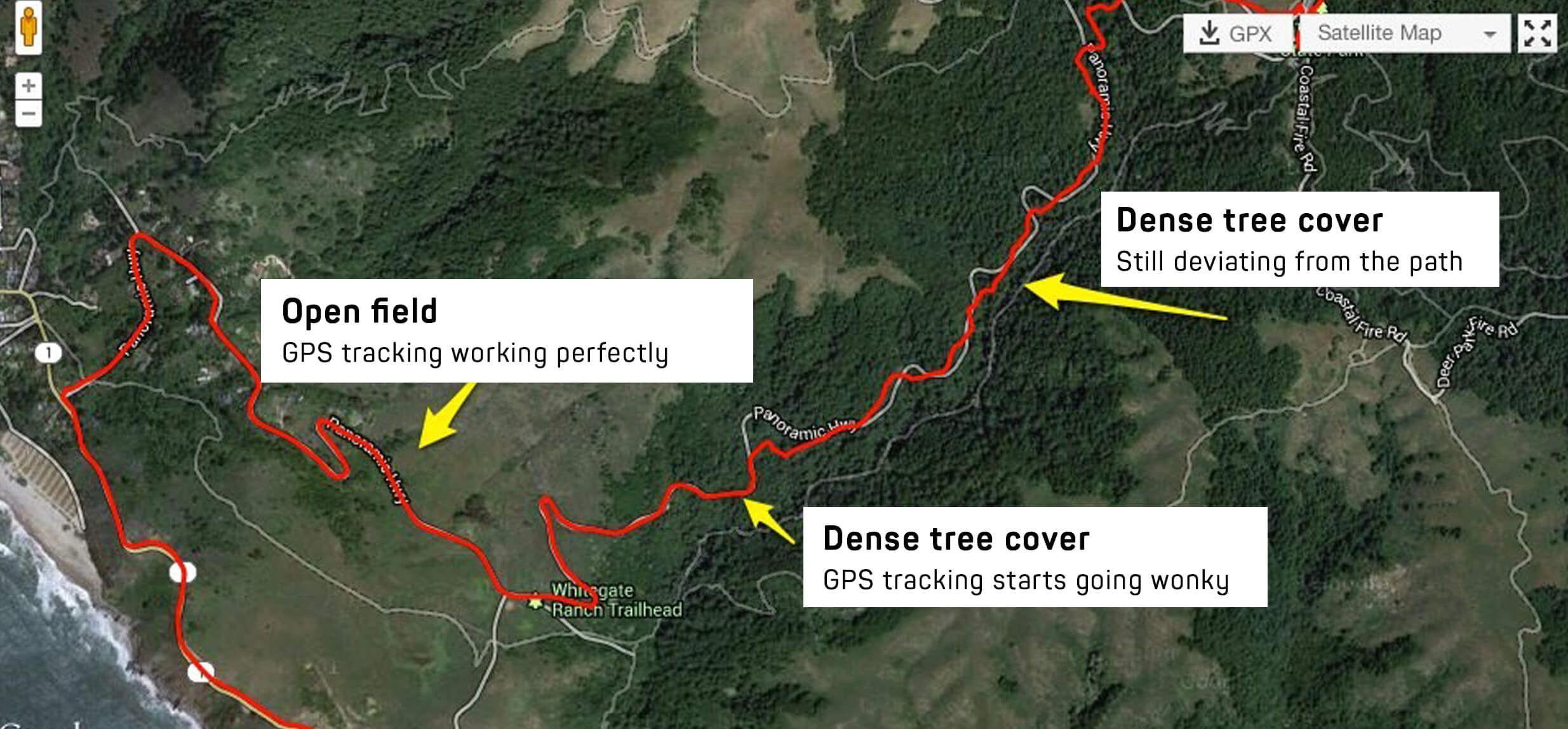
5. The signal is good, but the location will suddenly jump or will show that you are still moving, even if you have stopped.
These sort of ghosting GPS images, or a GPS with a mind of its own is most often caused by weak GPS signals. Check your antenna connection and line of sight and try moving either of them to a higher position in the cabin or the exterior of your farm machinery or vehicle.
Most devices have pretty good GPS antennas and they get good reception but there are still a few cheaper devices using GPS that have low quality antennas and that won’t allow you to plug in a stronger antenna. If location accuracy is crucial (and in most farming operations it usually is!) always try to choose a GPS device that has a good antenna or that can be upgraded with a more powerful external GPS antenna.
6. The map that is meant to be tracking location is just showing up as a mess of lines?
When using a GPS device that is connected to a tracking server it may take a few minutes to correctly find a GPS location as it will be trying to load a history. In this case it’s likely that the device has been switched on or calibrated to the time zone where it was manufactured or last used so you might be experiencing another problem, and it might be caused by incorrect time zone settings (refer to point 4 above).
Is GPS tracking the best solution? What are the downfalls of GPS?
There are so many satellites in space and global satellite companies working together that even the most basic devices that offer location tracking are accurate, often within a few meters. However, as IoT devices (Internet of Things, i.e. things connected to the internet), or device-to-device tracking applications become more popular, GPS is not necessarily the most reliable or affordable solution.
IoT devices that include tracking and position/location monitoring systems are usually battery powered and require long life batteries to remain switched on and able to receive a signal. The reason for this is because the GPS radio receiver has to be on to receive the signals and this consumes energy. Calculating the location also consumes energy as does showing the map or coordinates on a screen.
So, although they may be accurate, GPS devices use a lot of power coordinating their positions (this is why your phone battery runs out faster when you’re using the maps feature).
As GPS requires line of sight it may work indoors near windows, but the accuracy will drop significantly. It won’t, however, work in underground storerooms or cellars. There may also be times when your tracking software may lose a signal and instead use the last reliable location.
How do I get started with GPS on my farm?
The best way to understand how GPS tracking solutions may be beneficial to your farming operation is to speak directly with vendors. AgTech Finder will help you narrow down which solutions may be well suited to your farm, then by contacting the providers directly they will be able to provide specific advice on how and where GPS tracking may add the most value to your farm.
To help get to the crux of GPS tracking, here are a few questions that may help guide your search:
- What will be the initial and ongoing costs of using a GPS solution?
- What sort of technical know-how is required to use GPS?
- How well can GPS solutions work with other technology I currently use on my farm?
- What level of connectivity with the Internet does the GPS device I’m looking at require to be effective? Would it work where I’m planning to put it to use?
- What is the customer support like? If the GPS equipment I buy doesn’t work or breaks down, who can I contact and how quickly will they respond?
- Have you provided GPS solutions to any other customers who are in a similar position to me? What were some of the benefits that they’ve seen?
If you would like to know more about GPS solutions for farming and agribusiness email agtechfinder@foodagility.com, or join the AgTech Finder community on Facebook, Twitter and LinkedIn.
Jargon and other acronyms you might hear used with tracking technology…
Gateway
A gateway is a network point (or node) that regulate Internet traffic flowing between two dissimilar networks, most often a secure network and an unsecure network. A gateway is a node (router) in a computer network, a key stopping point for data on its way to or from other networks. Thanks to gateways, we are able to communicate and send data back and forth. The Internet wouldn’t be any use to us without gateways (as well as a lot of other hardware and software).
IP Address
An IP address consists of 4 numbers (0-255) separated by a decimal point. Eg. 10.5.20.254
The number is unique and identifies each computer using a network. If you need help finding the IP address of the computer your on this is a helpful step by step guide.
Router
A router is a networking device that forwards data packets between computer networks. A ‘packet’ is typically forwarded from one router to another router through the networks that constitute an internetwork (e.g. the Internet) until it reaches its destination node.
APN
APN is short of Access Point Name and provides a phone with the information needed to connect to wireless service. It can be changed by adding a new APN profile with information from the carrier in the phone or in your GPS device settings.
PDN
The APN identifies the packet data network that a mobile data user wants to communicate with. In addition to identifying a PDN, an APN may also be used to define the type of service, (e.g. connection to Wireless Application Protocol (WAP) server, Multimedia Messaging Service (MMS)) that is provided by the PDN. APN is used in 3GPP data access networks, e.g. General Packet Radio Service (GPRS), evolved packet core (EPC).
The Cloud
This term is used to describe a global network of servers around the globe which are linked together operate as a single ecosystem. These servers are designed to either store and manage data, run applications or deliver content or a service such as streaming videos, web email, office productivity software or social media. Instead of accessing files and data from a local or personal computer, using the Cloud you can access them online so long as you can connect to the Internet.
IoT (Internet of Things)
The Internet of Things, commonly shortened to IoT, is a term that is used across sectors to refer to a system in which devices, sensors or machinery (i.e. “Things”) can be wirelessly connected to each other via the internet. Read a good article about IoT here.
GNSS (Global Navigation Satellite Systems)
GNSS stands for Global Navigation Satellite System and is the standard generic term for satellite navigation systems that provide autonomous geo-spatial positioning with global coverage.
Bluetooth and Bluetooth Low Energy (BLE)
Bluetooth is a wireless technology standard for exchanging data between fixed and mobile devices over short distances. Bluetooth Low Energy (BLE) and ‘classic’ Bluetooth operate in similar ways. The main benefit of BLE is that it operates in sleep mode and awakens only when a connection is initiated. Consequently, a BLE device offers power consumption that translates to significant power savings over Classic Bluetooth. BLE devices can be powered by a coin cell battery for one to five years – however this is very much dependent upon how often the device has to wake up and transmit data.
Posted in Farmer Advice
You Might Also Like
Jul 08 2026
New era for AgTech Finder to deliver opportunities for farmers and tech companies
Change in ownership announced, with REALM Group to lead the next phase of the digital platform.
Read MoreJul 23 2025
Low yields from wheat production? Here’s why.
For the past two decades, agronomists and farmers have been trying to solve the problem of low yields using Variable Rate Fertilisation application. However, yield is only half of the equation. In-field…
Read MoreMay 25 2025
Get more from your livestock data with these six agtech solutions
Farmers across Australia are producing more data than ever. But much of it remains frustratingly siloed. Here’s how you can get the most from your data as a livestock producer.
Read MoreMay 20 2025
Purchasing AgTech? Ask yourself these five questions first.
Whether it’s your first time, or you’ve already got plenty of technology in operation – asking the right questions ensures you take the best approach.
Read MoreGet listed on AgTech Finder.
AgTech Finder helps Australian farmers and producers find the product that’s right for them.
Register now to be a part of the community, get access to a national platform and start gaining insights to improve your products.